Thursday, November 14, 2013

Savandurga - Monolithic climb

Come a holiday, it's good time to trek.
2013 Gandhi jayanthi falling on a wednesday provided me with an oppurtunity to trek somewhere near Bangalore and I zeroed in on savandurga.
About this place, its one of the largest monolithic stucture in asia, (hmm.. rest look up at wiki)

Getting there:
Well you can find a lot of information on web how to get there its, on this particular day, this being a public holiday we found quite a crowd which gave me a feeling that I'm just walking in a crowded street... (Well almost) so getting there on your own transport is straight forward.
For folks using pubic transport, I will briefly lay down as to how WE got there
For us getting to a trek location is always an adventure, and using public transport increases this quotient a bit..
How WE got there (am I repeating this too much?) In chronoligical order... (disclaimer: all the time here is approximate)
6.30AM:  Reach K.R.Market
7.00AM: After breakfast, inquire where to catch bus for magadi? folks ask to go to kalasipalyam bus-stand
7.15AM: After inquiry and a little walk we arrive to an open ground with lots or buses
7.25AM: after some more inquiry we found a private bus going on magadi road
9.05AM: Get down as Ram-nagar road junction and catch a private share auto to savandurga (you get ksrtc buses as well)
9.30AM: We are at hill base.
long story short: To reach by public transport, catch a bus from KR Market which goes on magadi road and get down at ramnagar junction and take a share auto from there to hill base.and since there is a temple near the hill base share autos keep plying frequently.

About the trek..
Well the trek was just about our usual struggle, it was a little tricky as it had rained and there were occasional drizzle and this was a pure rock climb (not in terms of vertical angle) so it was quite slippery.
starting the trek..


near to hill top.. there were quite a crowd and the folks in background were just a couple of them..

seems and ancient structure.. good site for evening campfire.. and some of them had camped overnight

Its a good resting place too...

Nandi temple at hill top which most people visit

As usual view from top is great, but this hill had a lot of small lakes surrounding it, I think there is a forest range near by.

Savandurga hill.. may not look much in the pic, but climbing it does take some stamina..

Coming back we couldn't find any share auto so we had to walk till the main road junction and hitch a cargo auto ride till the public transport junction.
All in all it was a unique experience... had there been no crowd it would have been a thrilling experience, but one can't be choosers in this case.

Thursday, November 1, 2012

Wetty Dewy trek on pallikonda forest range hill

It's been some time since I had trekked, so I badly wanted to do a proper trek, no matter how small it may be, we zeroed in on a hill near pallikonda, since it was the only one we have avoided along the higway around vellore.
infact I had grossly underestimated its thoughness and had really thought the trek can be finished in half an hour,but we got quite a few pleasant surprises during the trek.

We reached pallikonda around 6.50AM so by the time we reached the hill base it was 7.00,
as we neared we found barbed wire fences around the base, enquiring a passing localite for entering the hill
we found that we had to go through the forest office round the corner, this was a big surprise as we never knew this hill was treated as a forest range (though isolated and small) fair enough we did find one and started our trek.
It was a foggy winter morning and hill was covered with dense fog and cloud.

As most hills like these which are near civilization in india will invariably have a small temple up there, this one had too and there were some steps which were laid for few feets, after that there were some mud based trail which was supposed to lead to it, such paths are usuallly good for some first time trekkers, but hey! I'm not the ones to take it as I usually trek to get a sense of adventure.
So as usual we took the wilder route for our ascend, and it turned out to be quite a unique one for us. The hill was covered with thick grasses due to recent rain and it was covered with lots of morning dew, slowly as we ascended we started feeling our pants and shoes getting wet, by the time we reached some height it was quite wet.On our way we found some birds (obviously it tough clicking them as they are not very photo friendly so no pics) and a gang of slimy worms every now and then which we had to carefully avoid.
Heavy dew drops on grasses which dampened our shoes... and yes I know my photography sucks!

Slimy worms present all along the way.. (don't puke now)

Never underestimate..
Half and hour had passed since we started and as per my calculation we should have finished our trek by now, but we were no where near the peak(ahem.. mountaineers pls excuse), its a strange thing, when things don't go according to your calculation mind starts playing games and suddenly mujju (my trek partner, in case you are new to chronicles of my treks) was feeling hungry and I was feeling thirsty, (Old readers of my chronicles please excuse and kindly wander your attention to other life's problems as you won't be interested in next few lines)
Ah yes, my dear new readers... yes I know you would suggest why not dig in my bag and get a pack of snacks and a bottle of elixir saved for such occasions, but alas! I want you to pay attention to our trek rules we have set, "No water.. no snacks.." and this has time and again made our lives miserable, and since this was a early morning trek, our stomach was practically empty, except for a little cup of tea,
So we started to feel that we will not make it to the peak and would have to return halfway back.
"shame, shame.. calling yourself trekkers.." well that was the call from inside, and some how this made us go forth with some purpose after all one has their own image to live up to.. Atleast I learned a lesson to "never underestimate" a hill as sometimes experience can be misleading (it's a different matter if I will remember it though).
Nearing halfway and it started getting dense with lots of small trees.

Halfway..Perfect photo opportunity
As we neared half way it started getting a bit dense with more trees showing up, it had a feel of forest and we started liking it, we found a big rock which we used up to rest and were, here we clicked some snaps, and I pretty much found the perfect photo op of sun rays filtering through clouds which I have been trying to take for long, also since it was foggy, the feel was we were between the clouds and the pics turned out real great.
A feel of being on cloud..

brief moment of sun rays filtering through fog and we almost got the perfect pic.


Another Management Lesson..
We started estimating our chances of reaching the peak in our present condition and we were feeling still negative about it, the peak looked really far for some reason after lot of delibrations I said let's climb till a certain rock which seemed to be at a reachable height, mujahid commented "Small goals always helps in achieving bigger goals", Ah! good old management lesson, well atleast it did and after some struggle reaching the rock made the peak within reaching distance,
Mujju took the initiative for the final assault and we managed to reach it atlast.
Reaching the peak reconfirmed the old satisfaction that a trek is incomplete unless you reach the peak, the back side was densely covered with thick trees and bushes, I suspect there should be some mid-size wild animals atleast as we found some unfamiliar animal "shit" (pardon my language)
Attitude on top!

We took some pics and rested on top, we badly wanted to dry our feets so we let the shoes dry on the sun.

After a while we descended, and it turned out a little tricky as I got some bad impacts due to slipping, we were careful to follow a safe descent route and we pretty much took the muddy trail down for most part.
by the time we reached the base it was 9.50, so all in all it was a trek almost close to 3 hours which was good and refreshing.
I would definitely recommend it to others if they are looking for a quick adventure over a weekend.
More pics of hill are here Trek pics

Monday, April 2, 2012

Dirt Trek on a Charred Yelagiri!

Prologue..
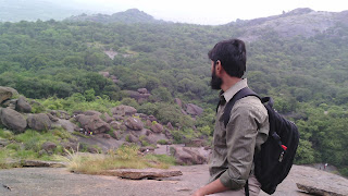
Mujahid was visiting my home town (Ambur) after a long time (actually it is his hometown as well) so we planned our long pending trek to the yelagiri this week,
but I had never expected it to turn out a dirt trek of sort,
I usually return to my hometown every week from bangalore, this time during my return journey (on thursday night) I noticed from the bus that a hill was on fire from a far near vaniyambadi,
This I thought was some small hilllocks in which the dry grass were burning due to some sunburn, but as I neared the location, I kind of knew that it had to be yelagiri hills, and the scale of the fire set was actually huge,
pretty much the whole left side of the grassy slope and quite a few adjascent slopes near the hair pin bends were affected and the sight when I trekked it was that of a real mess.
I enquired the locals during my trek if the fire was man made and couple of them confirmed that it was the doing of some miscreants, and later when I googled I found it true that indeed done by some
underhanded folks... (though I don't know the reason..),
Now some of you reading this will be thinking, "hey wait up! are we reading some newspaper report on some domestic crime which this fellow is circulating for free! are we at the wrong place?? should I refresh my page to get the actual blog.. etc etc, so on and what not!"
well folks, I assure you thats not the case... although I'm very much against this henious act and believe me I sweared few inexplicable words against these miscreants...
The reason I'm mentioning this is because this incident had an impact on our trek though I must shamefully admit that it was a positive one...

Planning and setting out..
Since yelagiri is a considerably huge hill (read tall and 920 meters to be exact), we planned to have enough time to ascent/descent it, I estimated it to take around 4 hours, and this time we had a hard limit for our return which was around 11.15AM as there were some social gatherings to be attended back in town, so we planned to set out around 5.00AM in the morning which would give us around 6 hours.
This was night before trek and the night before trek is usually a lively one in my home as I would be generally goading few of my cousins and brothers to head out with me which would end up futile always,
and some are even shameless as they outright say "idu nambulku illae bai.." (its not for me dude), Tch Tch.. I mean where have the mens gone these days...(Am I the only one?)
even showing them a thousand "man vs wild" episode will not be enough to inspire them for an adventure or for that matter narrating the inspiring story of George Mallory...
They will just ask with a raised eye brow.. "George who?"
and its at times like this is that I'm thankful to mujju who atleast gives me company on these treks....
hmm... where was I again?

Anyways.. as planned we (Me and mujju) setout the next morning around 5.15 and this time it was a bus ride and reached vaniyambadi around 6.00, we desperately wanted to have something to fill our stomachs and could only find a tea kade (tea shop), so after a few tut-tutting about lack of food options at this hour of day and a cup of tea, we caught a town bus to ponneri village which is actually at the yelagiri hill base.

By the time we reached the village, it was around 6.20AM and were a bit off from schedule..and since there was no ride, we had to walk for about 2KM to reach the hairpin bend road..as we neared the hill base, a couple of youngsters zoomed past us in their bikes and they gave us a look which said .. "what the hell are these idiots doing? trying to walk  up the hill? look how cool we are riding these bikes..", I wanted to take the nearest stone and hurl at these eye-sores..., I mean #$#@ 2#$#@ %&^%&.. ok ok, control control..

so effectively our trek started around 6.40.
Road from ponneri to hill base

Dead ends galore..
since this was supposed to be a proper hill climb we were conscious to avoid the road, but we wanted to trek adjacent to the road just to be safe, in hindsight this was a bad decision as the road to the hill top has been cut in a region where there are lot of thorny bushes..
our first attemt was in a small opening which we found near first hair pin bend, it looked like a narrow clear opening so we jumped up the fence and walked a bit far but found it to be rather dense and thorny after a few yards, we tried to find some clear path here and gave up after some time...
1st dead end near 1st HP bend..
back again on road, a little further we found an old man cutting dry grasses just above the road, this time we thought for sure that there should be an opening and started climbing up, generally not accustomed to seeing trekkers asked us, "Yaen paa vandi varlae-aa?" (havent your pickup ride arrived yet?) mistaking us for tourists.. we had to set this notion false and enquired about the clear way up, he said its impossible to climb any futher as it thorny, true to his advise we found another dead end and made our way back to road..

Old man collecting grasses... place we tried second opening..
returning back to road after 2nd failure..

Clear opening atlast..
we were reluctantly walking up the road desperately trying to deny the fact that its impossible to find a clear climb path...
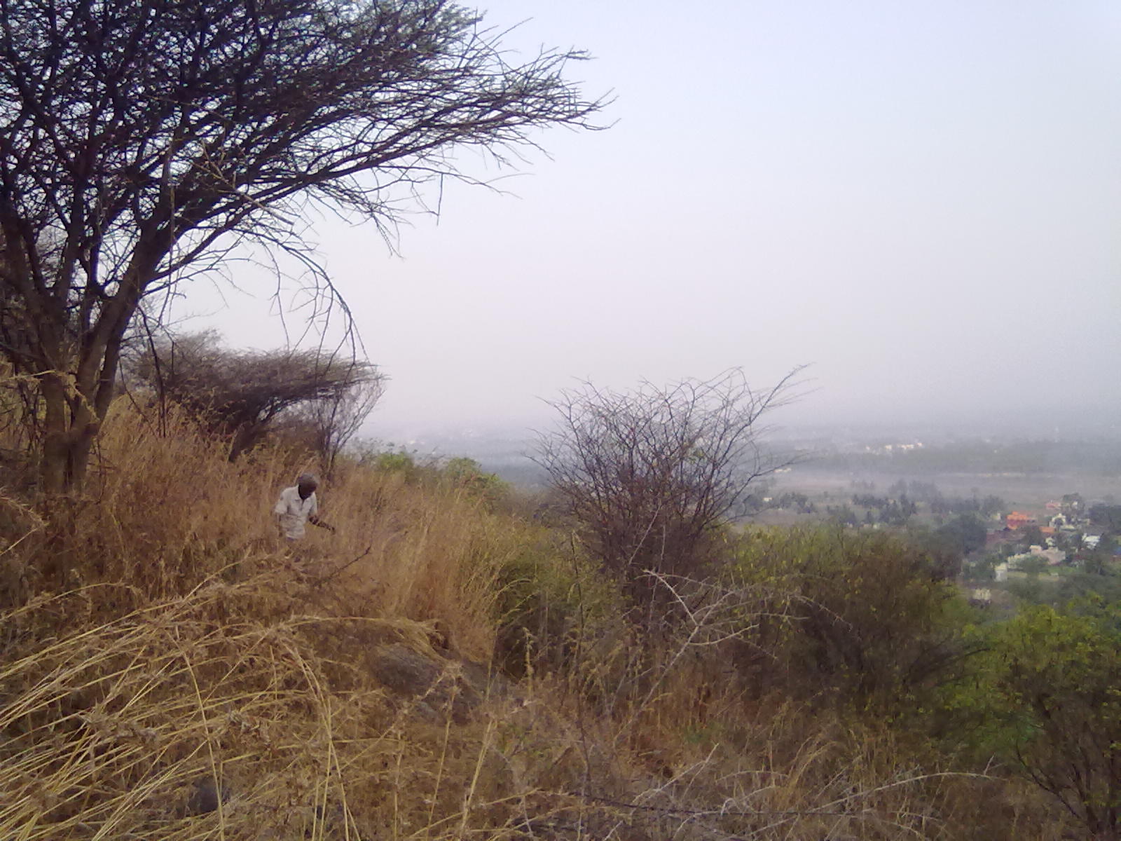
and fortunately at the 2nd hairpin bend we finally found one, we hurriedly walked up to the clearing, but as we stepped into it, it was a huge layer of black charred up soil and this continued a long way up.., some locals were cutting down some dry twigs and they confirmed the reason about someone setting up the fire...
the whole site was a mess unlike to what I have seen of yelagiri in the past, the only thing I can see in my front was a rubble of rocks covered in black charcoal...
The locals again warned this time not to take this route and the reason was it would dirty your clothes.. I waived the suggestion non-chalantly... after all trekking does leave a few dirts on your clothes..
2nd HP bend where we found clear opening

but it was rubble of rocks covered in black charcoal

Fast climb..
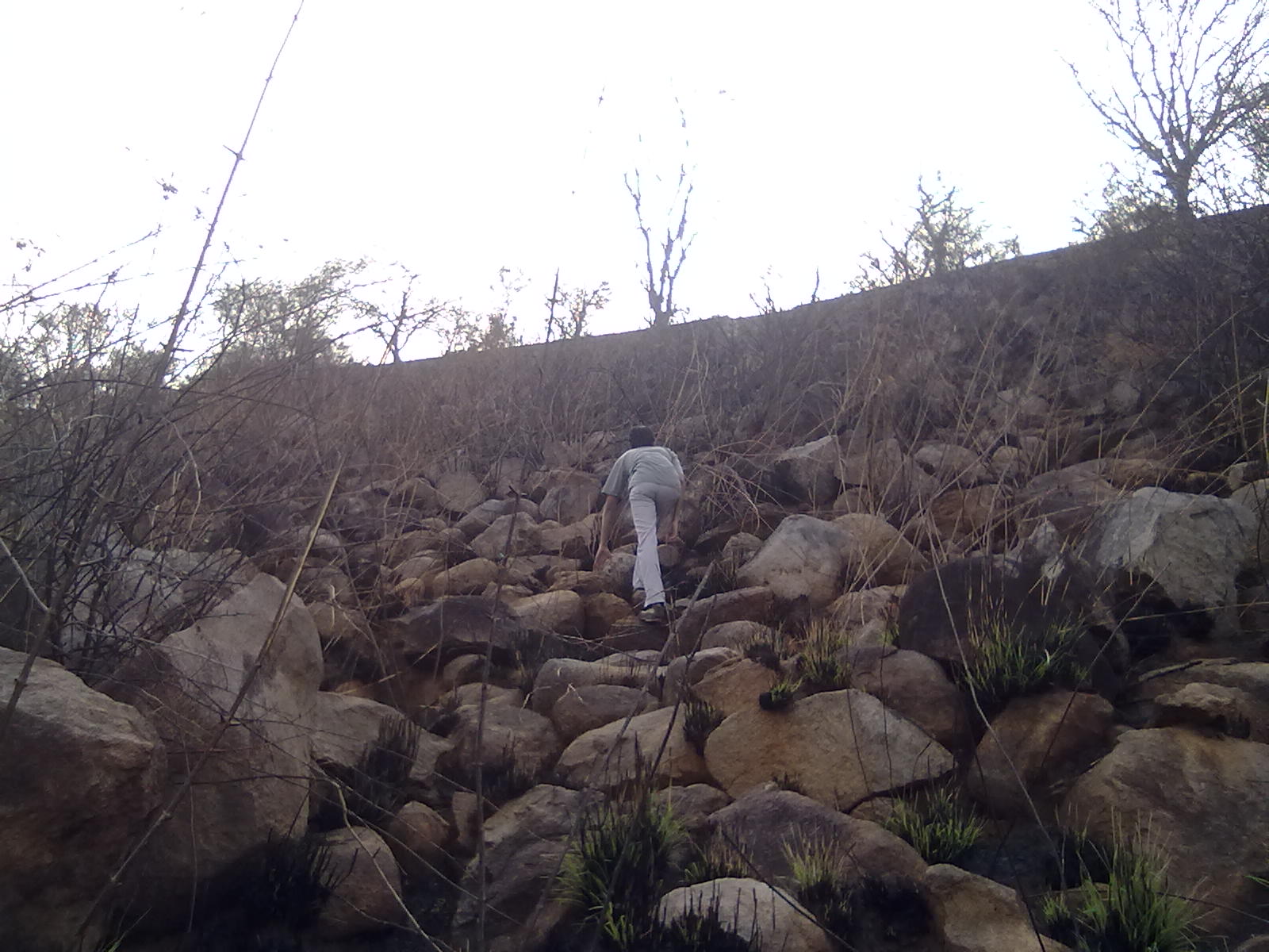
Although an eyesore but the site of naked rocks piled up one above another gave off a feeling of appealing climb and we took up the challenge, we started the climb and
also shamefully reminded ourselves to have depended on the fire for a proper climb..
The climbing of rocks soon turned out to be an adrenaline rush and not having climbed a hill for a long time gave both of us a some sort of excitement,
It was a fast climb up the rocks..

I could feel the excitement of the clear unhindered climb, the first leg of climbing took us near the 4th hairpin bend road, but the excitment was such that we did not stop the climb one bit, in the process by the time we reached near 6th hair pin bend, we had negotiated some tough and difficult rock climbs and this was turning out to be one fun ride.
by this time we were out of breath and some rest was in the offing..
while resting mujju pointed to my pants and it was a horrible sight, the whole lower half part was covered up in dirt lines of black charcoal from the unburnt twigs,
probably this is what the locals referred, and there were traces of black dirt in back of the t-shirt as well, this was the first time to trek in such a dirt and hence I call this "Dirt trek"
resting near 6th hairpin bent

Dead end again..
We hoped the clearing to lead us to some considerable height and we continued our trek again in the the rock rubbles, only after some time we started noticing some unburnt thorny bushes showing up..
we continued our trek into these bushes as they were not so dense, hoping it would clear out after some height, but some how we ended up in dead end.., we tried couple of alternate openings further to the left and finally found ourselves surrounded by some of these bushes with narrow chance of escape,
we sat down here and contemplated as to what to do? this was the fifth time in todays trek we had come up at a dead end, it was as if the hill was signalling that today is not the day...
we took the narrow escape route out of this bushes and decided that we will give one final push to see if we can find a further path to climb up and explored a bit more to the left.
But we found ourselves tangled between thorny bushes

Open valley! a ray of hope...
further left we found the edge of the hill and there was a valley running in between this edge and the other, these valleys are usually dense as water will run down it during rainy days, but the summer heat had thinned this considerably, on any other day without the fire this scene would have looked spectacular with the the hill slope covered in grass, and from this point we could see the bridge connecting these two edges (This probably would have been around 10th hairpin bend around 600-650Meters), but this just wasn't our day, as just further up some bushes were again hindering the path,

Opening with a ray of hope
Contemplating a way to reach other slope
The time was now around 9.00 and that hardly gave us about 1 hour to complete the climb, the other hill edge which was in front of us was actually the grassy slope now barren, and this is the slope which should have actually been taken by us as there are no hindrances there, we were discussing if we should restart our trek on the other slope and checking for routes to reach it... the phone rang..

Leave to climb another day...
hmm! wait am I giving a mysterious intent here?, The phone rang but this call was not some black mail call or anything like I have to do X to avoid Y and end up doing Z, this call was from mujju's father to make it in time for the social gathering... Damn! why do these mobile tower work in hills, Next time I should bring a jamming device along with me to avoid such calls, anyways it was probably time to give up on one thing and we decided to give up the successful ascent, probably it was not worth climbing a charred hill, so as sometimes  battles end up in dead lock situation and the warriors return to live and fight another day! we both had to leave to climb another day...
The descent took another 45 mins and by the time we reached ponneri village it was around 10.15 which gave enough time to make it back in time.
but the battle is not over yet and hopefully we will return to complete the trek on a yelagiri which will give extra challenge with its grasses

here is the complete gallery of the trek

PS: after returning I proudly showed off the dirt on my pant! and I got an earful from my mom and she downright turned down to wash it,
These are the comments after seeing my pant..
Mom: "Teri joru ku bol ko dho.." (ask your wife to wash it) (I doubt she will though..)
Grand Mom: "Yengeda poi vandaen.. yadavadu oole malai ku pone aa?" (where the hell did you do, did you go to some cheap hill)
Cousin: "rai muzzu! kaan re lidko aaya?" (hey muzzu, which dirt did you roll over?)
and some more sarcasm... aah! its tough being an adventurer..
by the way the pant was still lying unwashed last seen, wonder if I should frame it?


Framed


Wednesday, May 18, 2011

Random Pics which I took but which I Love...

I'm writing this post as its not possible to write individual blogs on these pics..
Perfectly Sunny..
This snap is from one of my weekly travels in NH46 to from bangalore to my hometown, This pic I took near a dhaba few Kilometers before krishnagiri, what was a random pic turned out a very beautiful one,
It just shows a Perfect blend of bright blue sky with ample clouds gelling well with the green rocky landscape..
Perfectly sunny!


Pefectly sunny.. with a little shade.

Lifting veil of mist..
This pic is from the backside of a small hill in my hometown,
Early morning as the sun is slowly rising the veil of mist is slowly lifting to show layers to hills one after another..
I was quite surprised that such a scene is there just on the outskirts of my place..
Lifting veil of Fog!

Is this switzerland..
This pic is from one of my recent treks "Nose dive hill" to be precise... When I later saw the pic, I couldn't believe this was the same place I trekked in summer heat... The trick might have been the angle in which I took the pic,
The pinkish sky with the back drop of hill layers... I couldn't help but wonder "Is this switzerland or kashmir?"..
Is this switzerland or kashmir?

The picture I drew..
Not every will post pics from USA like this one, this pic I took in Alviso (california) which is a pretty remote place in bay area.
some how I like scenes like these where a river is flowing serenely and as a child I have drawn pics like these so I took a couple of snaps of it..
people row their motor boats on this narrow river...
The picture I drew..


Friday, May 13, 2011

//Program Trek_at_MM_Hills.exe(cution) Version 1.0

/*
trek done in a hill near vaniyambadi in NH46 (chennai-bangalore highway)
distance from Ambur around 14KM, should take a left some where before reaching vaniyambadi
Implemented by : Me (Muzammil)
*/

class Trekkers; /*class here refers to category*/
Trekkers Me, Mujju; /*Me refers to Myself, Mujju nickname for mujahid my trek partner*/

Trekkers MainProgram()
{
    InitializeTrekProgram();
    StartTrekkkingOperation();
    FindCheckPoint();
    StartClimbing();
    CheckIfOperationClimbSuccesful();
   
    if(OperationStatus = Fail)
        return Zero;
   
    if(OperationStatus = Success)
        return (Me & Mujju);
}

/*No no people, don't leave yet, this is not a technical blog, its just a crazy way of depicting a trek that's all!, 
Technical help for ppl who don't know what a C++ program is
Me.SomeAction() refers to some action performed by me during the trek, same for Mujju.SomeAction */

InitializeTrekProgram()
{
    Me.WakeUpInMorning();
    Mujju.CameHome();
    Me.DrinkTea();/*ofcourse Me brush teeth*/
    Mujju.DrinkTea();
    Me.CheckTimeIts(6AM);
    Me.Drive_TVSMoped_Towards_Vaniyambadi_AlongWith(Mujju);
}

StartTrekkkingOperation()
{
    Me.Take_LeftTurn_At_NarrowLane_4KMBeforeVaniyambadi();
    Me.StopAtSuitableLocation();
    /*Me Worry some one will steal the precious TVS moped*/
    Me.SaysThis();
    Mujju.Says_NoOneStealsThisJunkTVSMoped_LetsStart();
    /*Me start walking after some prayer to God, Rs.1 in charity if TVS safe on return*/
}

FindCheckPoint()
{
    Me.LookAtHill();

Output: LookAtHill //hill we climbed


    WalkTowardsHill(Me, Mujju);
    Me.Says_DecideNearByCheckPoint_ForProperReturn();
    Mujju.Says_That_BanyanTree_LooksProperPointForReturn();
    /*Banyan Tree very old one, a proper symbol for indian village*/

BanyanTree //perfect check point for start and return


    WalkTowardsHill(Me,Mujju);
    //Operation needed some venturing to find hill base
}

//Trekkers Climb operation
Trekkers::Climb(Direction)
{
    while(NumberOfSteps  < /*less than*/ Required_NumberOfSteps)
    {
        if(Direction = UP)
        {
            TakeAStepUpTheHill();
        }
        else if(Direction = DOWN)
        {
            TakeAStepDownTheHill();
        }
    }
}

StartClimbing()
{
    Me.Climb(UP);
    Mujju.Climb(UP);
    TakeRestMidway_TakeSomeSnaps(Me, Mujju);
Midway scene: Children playing at base of hill


Some snaps//Me Midway
}

CheckIfOperationClimbSuccesful()
{
    ReachTheTop(Me, Mujju);
    TakeSomeSnaps(Me, Mujju);
Mujju //on top
Me //on top

     Me.SeeAnotherPeak_AfterADownHill_Says(OperationStatus = Fail);
Another peak? //operation failed?

    Mujju.Says_I_NeedToReturnEarly_ThisPeakIsGoodEnough_Says(OperationStatus = Success);
    // heck Mujju wants to return, not Zero, pls chk MainProgram()

    Me.Climb(DOWN)
    Mujju.Climb(DOWN);

    Mujju.SwingsInBanyanTree_Says_TakeSnapToMakeTrekMemorable();
   //oops phone Memory overflow, output snap not saved, hard luck pal!
}

//if you have come till this point, then congrats you are truly a OOPs programmer

Tuesday, April 19, 2011

Anthargange - Rocky trek

Well this was my first trek of its kind, a proper hill climbing....
Anthargange is a hill located in kolar (karnataka), its usually famous for the temple situated midway, but its also a trekkers hub especially for techies who come in group for rappelling during weekends....

Best way to get there is using a two wheeler or car, kolar is around 70KMs from bangalore, and once you reach there anyone will direct you to Anthargange..

Here are the pics from the trek


Planning...
Selva (My colleague) who was recently infected by a disease called trekking was itching to go on a short trek and was not finding anyone to accompany him, he casually mentioned about his desire to trek anthargange and asked if I would like to join. I have been pretty much alien to trekking till then, so I gave it some thought....
I have been watching this show called Man vs Wild and I had wanted to go on such adventures as that guy on TV (bear grylls actually)... This seemed to be the perfect opportunity to kick start that...
It was decided that we will go the following Saturday (10-Jan-2009)(Yes, this blog is a few years too late... but don't mind that), I was lucky that I said yes because that day was what made me turn a trekking freak..(well sort of atleast...) so let me say it here "Thank you selva"

Kick start ...
I had stayed overnight at selva's house and we had stuffed our backpacks with snacks and biscuit (especially Rs.3 tiger biscuit, cheap fellows) in case we got hungry during our trek....
We started in selva's bike early morning 6.30AM, fortunately selva has a proper bike (Unicorn to be precise) and not a moped which I have back home, so we zoomed to kolar from bangalore quite fast....
The bridge near KR-puram  was pretty much like a gateway to kolar....
KR-Puram bridge, Bangalore's gateway to Kolar
We had reached kolar around 8.00AM and it took some time asking the locals for a proper way to reach Anthargange, we finally got some approximate direction, and we decided to do a light breakfast... but... we were destined to trek with empty stomach as we couldn't find any proper hotel nearby the hill, we decided we will snack on our biscuits later and started towards the hill...
Anthargange hill
 We parked the bike in a near by house at the hill base, but selva was reluctant to leave his bike, I couldn't understand the reason, so I asked him why? he filled me in with these wise words ... "Ungalku theriyadhunga.. petrol yadhudthudvaanga., jagardiya irukkunum" (you don't know man! some one will steal petrol from the tank, you need to be careful) aah! the precious liquid,
well I couldn't say much to this, so he gave some instruction to the house owners to take care of his bike and what not and we were off....

Jack and jill went up the hill...
It was finally time to start and we were at the steps and I was thrilled taking those Initial steps.
Initial steps


There are proper steps which lead to the temple, selva wanted to take a more wilder route, so we took to the woods adjacent to the steps, this turned out to be very good by me, and by the time we reached the temple via this route we had had a mini adventure finding the way up, I had stumbled quite a few times by this time and selva filled me in with the reason, my shoes were the culprit, as the sole were worn off with no grip unsuitable for trekking (I made a mental note to buy a proper trekking shoes).
After the temple starts a very narrow uphill steps carved out in rocks and this seemed to be the way one needs to take, these steps lead you to a village situated in thie hill and we started the trial....
Some steps up the hill are smooth like this


Snack time...
It was quite some time since we started and our empty stomachs were acting up now...so we made a pit stop and the Rs.3 biscutis turned out a life saver, we filled our stomachs, and quenched some water and the mandatory photo session.
Pit stop for snack....
.. and mandatory photo session... (That's selva)
After a long climb we finally made it to the top of what was a small village, I was happy that I made it to the top and tired, I wanted to rest a bit and start back....
but wait....
Selva had different ideas.. he said "Yennangu unno mele poradhu irukku.." (we still need to go to the top..) I was confused, whats with this fellow I thought, I didn't see anything else to climb...
he pointed me to a smaller rocky hill nearby, apparently that is the actual peak for this hill, I desperately wanted to go back as I was tired, but after countless reasoning with him this adamant guy didn't back out...
I couldn't do much... He had the bike which will take me back so I needed to stick with him...(poor me)

Reaching the actual peak..
we started towards this hill, but we could find a proper way to enter it, we roamed up and down the field but to no avail, a farmer woman who was going near by came to our rescue,
Selva blurted "Beta" pointing towards the hill, I was confused why is he talking about sons with this woman,
the woman seemed to have understood and asked us to follow her, we followed her (selva enlightened me in with the vocablary, Beta in kannada means hill) she took us through some rock and gave us some instructions on how to reach the top and stood expectantly... it took us some time to understand, then we stumbled into our pockets to take out some loose change and place it in her palms.... she went off happliy
(I cursed the techies under my breath who seem to have corrupted these villagers with greed for loose change, I certainly didn't like it as it put a hole in my pocket...hmph!)

We had finally caught on to the trial and we reached a point what seemed to be the top to me, the cool breeze up there was refreshing, and I wanted to relax, we took some snaps here
And I thought "finally time to return"... but no... Mr.Selva had more other plans....he pointed to some rocks which were at an elevated height, he said the actual peak lies up there and we need to go up there....
I wanted to cry, random thoughts shot through my mind "Man I'm not even married yet and he wants me to die already.. does he have a death wish...? "
but having realised this fellow is not gonna back out, I had no choice but to follow....
we explored some mini caves in search of the way up and we finally found some slippery rocky path to the peak...
In search of a way up?
We finally made it to the peak and I must say it was worth all the effort, the peak is always the point of satisfaction and I realised that a hill trek is incomplete if you don't make it all the way up...
The breeze up here was cooler and we braced it... it felt like it took away all the tiring effort from out body
Point of satisfaction


more other ideas..
unfortunately there was a rock boulder on the peak which was dangerously placed, selva blurted a crazy idea again... "adukku mele pona than acutualla peak ku pona maadri.." (If we go on top of that boulder only then it means we made it to top), I gave it a look and decided, I'm no edmund hillary on a mission to scale Mt.Everest, (besides I'm not married yet to do any thing more dangerous) I said "Illae naka illae" (No means no) resolutely and I knew even selva realised it was dangerous to try climbing it.

Jack and jill went down the hill...
It was finally time to return and we started back, the climb down hill was mostly without incident, except for a village woman asking for some money which we tactically avoided (hey! no freebies ...)
We saw a group of techies who had reached the hill around afternoon they were there to do rappelling...
we ignored them and continued our way down...
We reached the kolar town by afternoon 1.00 PM had lunch and we both went back our own ways...

Monday, April 18, 2011

Nose dive hill

There is a hill near by which I usually find beckoning me for a climb whenever I travel towards chennai on NH46,
I finally found time to do it this week, turns out it is around 12KMs from Ambur this is just before a village called madanur.
Here are some snaps from the trek if you are bored to read

Start from home...
It was the usual.... my partner came to my home after fajr (that is around 6.00 AM) I had barely woken...
and after the usual lecture from my grandpa about not to go out in for trek as it was summer and you will lose face complexion and be careful during the trek and what not... we tiptoed our way out in SUPER XL TVS moped (ahem its not  a super fast bike you see), we filled up the moped tank with 0.66Litres of petrol and were rolling on towards madanur a near by village...

We usually don't plan which hill to trek before heading out and it happens on the run, after crossing the flyover near pachakuppam a hill range with 3 adjacent hills start, these hill are usually thorny with no gateway to climb to top, we had  attempted a climb in one of them sometime back but failed due as there was no much room to enter it.
It is one these hills actually the last one which has a unique shaped peak and I had wanted to climb it for sometime now for some reason I call it nosedive hill, I slowed down the moped (which was going super fast at 25KMPH) near this hill desperately looking for a opening, the speed-o-meter was reading 5KMPH and I barked a order at my partner .. "kya to bhi opening milta kya dekh?" (Check if there is any opening?)

Bless his sharp eyes he promptly replied "wahan dekh muzzu! ek barik lane jaata dekh" (Look ahead muzzu, a narrow lane is opening up there) well Muzzu is my nickname u see...
The hill we climbed. we call it nose dive hill...

Fair enough there was a small muddy lane about 2 feet wide going into the hill with thorny bushes all around. we pulled over and were contemplating to go inside or not, fortunately we saw a local village man with his lungi tied above the knees and his short clearly visible walking down the muddy lane into the hill, we hurriedly followed him, I asked him "malai mele porattuku wali irukka?" (is there a way to up the hill top?), he didn't stop but was advancing onwards, I got a feeling he might not oblige to the question, but as if he was used to the question he answered all the things we need to know while walking and it was really heplful.

Narrow lane leading from highway to the hill base..

Fortunately the state government had made a narrow mud trial from the base to till top of the hill (Apparently there is a token temple on the top). This trial was the only way to climb the hill as all around the hill the only thing you could find was thorny bushes, even this trial was not a safe one as it was carved out between these flesh in a thorn(y) bushes and our steps for most of the part up and down the hill had be taken with a lot of care and maneuver to avoid getting pricked or rashes which we did (well atleast for most part)

Midway...
Buddy resting midway

Halfway we found a resting spot which was good for resting as well as taking in a beautiful view of the scene below, I did my usual "stand on rock and looking at the peak" pose for a photograph and we both took a breather.
Stand on rock and look at peak!
No water policy gets our @r$&...
Since it was mid April (Summer) we were feeling the heat quiet early in the morning, we looked at each other we were already tired and sweaty by then,
Well you could say "Whats the big deal, you should have sipped a bottle of water or juice rested a bit and get a move on already" after all thats what all trekkers do right?
Unfortunately thats not so in our care, we both have a policy for our treks no water no refreshments, go bare hand and survive the wild for 4 hours without any external support, and it usually makes us suffer but this being summer it was making us suffer a lot more, we were feeling our dry lungs which had only seen a glass of water since we woke up and nothing else.... curses!

Power Ups...
We started our way up again and our pace was a little slow, each time I was clenching my fist and trying to "power up" to get the extra strength for me to carry on...
If you are wondering what this power up thing is, then I will explain it..
Its a thing which super heroes do in Animes and video games which makes their strength double or triple or fourble (ahem! Quadraple that is).....
I wanted to power up like this... alas! I'm human after all
Having realised that power ups are beyond me, I did a reality check, my partner was a little ahead by now and I called him "Mujju! wapas jaange ki...?" (Mujju shall we go back? Mujju is my partners nickname) this is usually the case in our trips when we tire out and one of us contemplate returning halfway.. this time it was my turn.My partner put up a brave front and asked me to rest up a bit so that we can start again.
Well I did this complaning 3 to 4 times before we finally reached the top.

On Top...
we finally made it to the peak and somehow I made it first, there was a layer of sunburned black grasses which was apparently effects of overdoing the sun-tan, (poor fellows)
I did my usual stand on top and look below pose for a snap and we explored the top a bit.
On top
The back side of the hill was a jungle unsuitable for exploring but there was a lone tree which stood majestically with a barren look, fresh fruit were seeping out of it (looked like mangoes to me...)
we appreciated it a bit and made our way back
Barren tree which caught out attention, this was facing the back side of the hill
Heading back...
After we came down, we rested a bit and started our way back, we wanted some refreshments badly after our dry trek and fortunately we found a tender coconut guy on our way back, we stopped and quenched our thirst before going back home...
We sipped to our hearts content...